
Our people

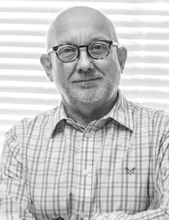
As CEO, Ken is responsible to the Board of Trustees of Oxford Archaeology for the leadership and effective operation of the business as a whole. He provides the strategic lead in the development of OA, both as a business in a competitive environment and as a charitable organisation involved in archaeological research and education for the public benefit.
After graduating in 1986 with a BSc (Hons) in Environmental Science, Ken worked as a geologist before transferring to archaeology in 1988. Since joining Oxford Archaeology in 1995, Ken has managed a wide range of archaeological projects and has particular experience in the management of complex mitigation schemes within large-scale infrastructure works, development of innovative and cost-effective approaches to archaeological mitigation, implementation of digital recording systems, databases and GIS analysis, and the provision of archaeological planning advice. He is also a qualified Health and Safety Advisor.
From 2016-2021, Ken was the Regional Manager in Oxford, responsible for the successful operation of that office.
He is a Member of the Chartered Institute for Archaeologists (MCIfA) and a Fellow of the Society of Antiquaries (FSA).
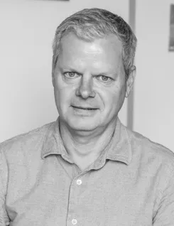
Andy joined Oxford Archaeology as Chief Financial Officer in March 2021. Andy is a very experienced financial professional and joined OA after spending over a decade in global roles in the international charity sector. Prior to this he worked in industry as well as in business and technology consultancy. In addition to financial management, Andy has extensive experience in business change, technology delivery, programme management and digital transformation. Andy is an Economics graduate and a qualified accountant with an MBA; he is also a Prince2 Practitioner and a Mental Health First Aider. He is currently studying Digital Transformation in the Charity Sector for his doctorate.
At OA, Andy has overall responsibility for the leadership of finance, legal, HR, property and administration across all aspects of the charity
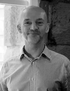
Dan has worked for Oxford Archaeology since 1992, starting as a volunteer and working his way up the ranks of the fieldwork team, with a focus on urban archaeology. He has extensive experience of project management and the pursuit of new contracts, gained from his years as a Senior Project Manager and then as head of the Oxford Archaeology Fieldwork and Contracts teams at our Oxford office. As COO, he is responsible for operations company-wide, ensuring quality and compliance across all Oxford Archaeology projects, including our ISO 9001, 14001 and 45001 certification. Dan leads on OA’s key infrastructure projects and partnerships, particularly the Oxford-Cotswold Archaeology JV.
Dan is responsible for Health, Safety and the Environment and is a Technical Member of the Institute of Safety and Health (IOSH). He also leads on training. He is a Director of the Federation of Archaeological Managers and Employers (FAME), a Member of the Chartered Institute for Archaeologists (MCIfA), and a Fellow of the Society of Antiquaries (FSA).
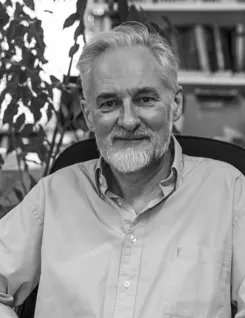
Alan has over 30 years' experience in professional archaeology in the UK and abroad and is a Member of the Chartered Institute for Archaeologists (MCIfA). He graduated in 1986 with a BA (Hons) in Ancient Mediterranean Studies from Bristol University, gained an MA (distinction) in 1988 at the Institute of Archaeology, UCL, and a PhD from Cambridge University in 1995.
Alan worked for Oxford Archaeology (OA) between 1995-7 and re-joined the company in 2001 working in our Lancaster office. He has managed a wide range of archaeological projects and has particular experience in the management of complex mitigation schemes within large-scale infrastructure works.
Since 2003, Alan has been the Operations Manager in Lancaster, is part of the Regional Management Team and also the Senior Management Team for OA. In his current role, he is responsible for fieldwork in the Lancaster office, overseeing quality and compliance across projects.
David has worked as a professional archaeologist for Oxford Archaeology since graduating from Reading University in 1996 with a first class honours degree in Archaeology. He is a Member of the Chartered Institute for Archaeologists (MCIfA). David has considerable project management experience in fieldwork, post-excavation and consultancy within a commercial environment has managed a portfolio of diverse projects including one of the largest urban regeneration developments in the country and a number of significant infrastructure schemes.
In his role as Head of Fieldwork David oversees the managers and projects undertaken by the Fieldwork Department and is responsible for the fieldwork programme, staff recruitment, deployment, training and reporting.

Liz oversees the post-excavation research and publications function at our Cambridge office. She has worked for Oxford Archaeology (and its predecessor) for twenty years. Her job is to manage all aspects of post-excavation work, including the finds, environmental and graphics teams. She also edits all of the academic and popular publications produced by the Cambridge team, ensuring that the highest academic standards are maintained and that projects are delivered on time to clients.
Having graduated from the University of Nottingham with a degree in Ancient History and Archaeology, she also has a PhD from the University of East Anglia. Liz has considerable experience in managing complex projects and specialises in urban Late Saxon and medieval archaeology, with particular interests in castle and cemetery studies.
Fraser has been working in British archaeology since the late 1980s and graduated with a BA in Archaeology and Prehistory from Sheffield University in 1995. He joined Oxford Archaeology in 1998 and is Regional Manager for our Lancaster office. Fraser is also a qualified Health and Safety Advisor and helps co-ordinate and implement health and safety policy.
He has considerable project management experience, overseeing projects, in both rural and urban environments, from tender through to publication. He has routinely undertaken work for the building construction, mineral extraction, transport and energy sectors, and has particular experience of large-scale infrastructure projects, including road schemes, long-distance pipelines and airports. Fraser has a keen interest in British prehistory, especially the Mesolithic and Neolithic periods and has expertise in lithic sites and waterlogged environments. Digital recording techniques and geospatial analyses are also areas of interest. Notable recent projects include the Asselby to Pannal Natural Gas Pipeline, the Isle of Man Airport Runway End Safety Area project, Carlisle Northern Development Route, the A487 Caernarfon to Bontnewydd Bypass, and the A585 Windy Harbour to Skippool Bypass.
Katrina has worked for Oxford Archaeology since 2004 and has over 15 years' experience in professional archaeology in the UK and abroad. As well as being OA South's Regional Manager, she also manages a portfolio of projects. She has a particular interest in early Roman Britain and the archaeology of World War II.
Katrina holds a PG Dip in Forensic Archaeology from Bournemouth University and an MA in Classical Studies from Victoria University of Wellington, New Zealand. She is an Associate of the Chartered Institute for Archaeologists (ACIfA).